


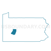
PINE TWP VTD 01, Indiana County, Pennsylvania
About
Outline

Summary
| Unique Area Identifier | 659996 |
| Name | PINE TWP VTD 01 |
| County | Indiana County |
| State | Pennsylvania |
| Area (square miles) | 16.59 |
| Land Area (square miles) | 16.57 |
| Water Area (square miles) | 0.02 |
| % of Land Area | 99.89 |
| % of Water Area | 0.11 |
| Latitude of the Internal Point | 40.57141890 |
| Longtitude of the Internal Point | -78.92173770 |
Maps


Graphs
Select a template below for downloading or customizing gragh for PINE TWP VTD 01, Indiana County, Pennsylvania


Neighbors
Neighoring Voting District (by Name) Neighboring Voting District on the Map
- BARR TWP VTD SOUTH, Cambria County, PA
- BLACKLICK TWP VTD 01, Cambria County, PA
- BLACKLICK TWP VTD 02, Cambria County, PA
- BRUSH VALLEY TWP Voting District, Indiana County, PA
- BUFFINGTON TWP VTD 01, Indiana County, PA
- CHERRYHILL TWP VTD 01, Indiana County, PA
- PINE TWP VTD 02, Indiana County, PA
- PINE TWP VTD 03, Indiana County, PA
Top 10 Neighboring County Subdivision (by Population) Neighboring County Subdivision on the Map
- Cherryhill township, Indiana County, PA (2,765)
- Barr township, Cambria County, PA (2,056)
- Pine township, Indiana County, PA (2,033)
- Blacklick township, Cambria County, PA (2,013)
- Brush Valley township, Indiana County, PA (1,858)
- Buffington township, Indiana County, PA (1,328)
Top 10 Neighboring Unified School District (by Population) Neighboring Unified School District on the Map
- United School District, PA (7,988)
- Northern Cambria School District, PA (7,898)
- Penns Manor Area School District, PA (6,155)
- Blacklick Valley School District, PA (5,161)
Top 10 Neighboring State Legislative District Lower Chamber (by Population) Neighboring State Legislative District Lower Chamber on the Map
- State House District 62, PA (60,760)
- State House District 60, PA (58,162)
- State House District 72, PA (58,097)
- State House District 73, PA (56,680)
Top 10 Neighboring State Legislative District Upper Chamber (by Population) Neighboring State Legislative District Upper Chamber on the Map
Top 10 Neighboring 111th Congressional District (by Population) Neighboring 111th Congressional District on the Map
Top 10 Neighboring Census Tract (by Population) Neighboring Census Tract on the Map
- Census Tract 9615, Indiana County, PA (4,172)
- Census Tract 9613, Indiana County, PA (4,122)
- Census Tract 118, Cambria County, PA (4,063)
- Census Tract 9614, Indiana County, PA (3,361)
- Census Tract 117, Cambria County, PA (2,427)